Log in
All resources
Create a design
947 Free Artworks of Maps Of The Netherlands
gemeente atlas van nederland - south holland
1860s maps of south holland
gemeente atlas van nederland - north holland
1860s maps of north holland
bibliothèque nationale de france
19th-century maps of rotterdam
krimpenerwaard in the 19th century
atlas van loon
gemeente atlas van nederland - north brabant
sanson maps of the netherlands
gemeente atlas van nederland - south holland
1860s maps of south holland
sanson maps of the netherlands
robert cordier (engraver)
gemeente atlas van nederland - south holland
1860s maps of south holland
windmills in hoorn, north holland
post mills in north holland
gemeente atlas van nederland - south holland
19th-century maps of rotterdam
gemeente atlas van nederland - south holland
1860s maps of south holland
gemeente atlas van nederland - south holland
1860s maps of south holland
gemeente atlas van nederland - south holland
1860s maps of south holland
gemeente atlas van nederland - south holland
1860s maps of south holland
maps of polders in south holland
17th-century maps of rotterdam
gemeente atlas van nederland - south holland
old maps of eiland van dordrecht
maps by pieter mortier
old maps of asia
old maps of limburg, netherlands
1884 in limburg (netherlands)
john spilsbury
puzzle maps
gemeente atlas van nederland - south holland
strevelshoek
gemeente atlas van nederland - south holland
maps of ameide
gemeente atlas van nederland - south holland
1860s maps of south holland
maps by pieter van der keere
old maps of zutphen
gemeente atlas van nederland - south holland
1860s maps of south holland
maps in the rijksmuseum amsterdam
published by frans buffa & zonen
gemeente atlas van nederland - south holland
1860s maps of south holland
gemeente atlas van nederland - south holland
maps of haastrecht
1580s maps of the netherlands
1580s maps of belgium
gemeente atlas van nederland - north holland
1860s maps of north holland
gemeente atlas van nederland - south holland
1860s maps of south holland
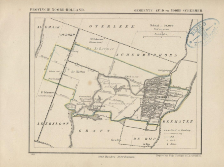
gemeente atlas van nederland - north holland
maps of schermer
gemeente atlas van nederland - south holland
1860s maps of south holland
gemeente atlas van nederland - south holland
maps of hendrik-ido-ambacht
sion, quarter of rijswijk
1712 maps
dutch 18th-century paintings in the rijksmuseum amsterdam
august christian hauck
gemeente atlas van nederland - south holland
1860s maps of south holland
gemeente atlas van nederland - south holland
1860s maps of south holland
gemeente atlas van nederland - south holland
19th-century maps of rotterdam
gemeente atlas van nederland - north holland
maps of bergen, north holland
old maps of middelburg, zeeland
atlas van loon
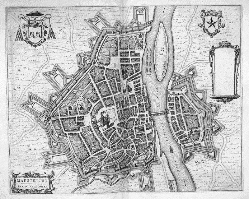
map of maastricht by willem and johannes blaeu (1649)
atlas beudeker
1610s maps of the netherlands
old maps of friesland
gemeente atlas van nederland - north brabant
maps of deurne, netherlands
gemeente atlas van nederland - north brabant
huisseling
gemeente atlas van nederland - north brabant
herpen
old maps of vlissingen
atlas van loon
gemeente atlas van nederland - north holland
19th-century maps of amsterdam
maps made in the 17th century
old maps of drenthe
gemeente atlas van nederland - south holland
1860s maps of south holland
gemeente atlas van nederland - south holland
maps of nieuwenhoorn
maps of krimpenerwaard
atlas novus (blaeu)
maps of nieuwpoort, south-holland
vestingwerken nieuwpoort
maps by isaak tirion
old maps of holland
maps by willem and johannes blaeu
old maps of leiden
gemeente atlas van nederland - north holland
old maps of amsterdam
gemeente atlas van nederland - south holland
1860s maps of south holland
gemeente atlas van nederland - south holland
maps of krimpen aan de lek
gemeente atlas van nederland - south holland
1860s maps of south holland
gemeente atlas van nederland - south holland
old maps of the hague
gemeente atlas van nederland - groningen
maps of hoogezand
gemeente atlas van nederland - south holland
old maps of brielle
gemeente atlas van nederland - south holland
19th-century maps of rotterdam
gemeente atlas van nederland - north holland
maps of beemster
gemeente atlas van nederland - south holland
maps of lisse
gemeente atlas van nederland - south holland
giessen (river south-holland)
balthasar florisz. van berckenrode
eran laor cartographic collection
gemeente atlas van nederland - south holland
1860s maps of south holland
gemeente atlas van nederland - south holland
maps of waddinxveen
gemeente atlas van nederland - south holland
giessen (river south-holland)
maps of nieuw-helvoet
nieuw-helvoet
sanson maps of the netherlands
1670s maps of the netherlands
gemeente atlas van nederland - north holland
old maps of alkmaar
gemeente atlas van nederland - south holland
19th-century maps of rotterdam
gemeente atlas van nederland - south holland
19th-century maps of rotterdam
cartouche (cartography)
cornelis de jode
1800s maps of the netherlands
evert maaskamp
gemeente atlas van nederland - south holland
maps of zoeterwoude
gemeente atlas van nederland - south holland
1860s maps of south holland
gemeente atlas van nederland - south holland
1860s maps of south holland
gemeente atlas van nederland - south holland
1860s maps of south holland
gemeente atlas van nederland - south holland
1860s maps of south holland
gemeente atlas van nederland - south holland
1860s maps of south holland
gemeente atlas van nederland - south holland
1860s maps of south holland
sanson maps of the netherlands
1670s maps of belgium
gemeente atlas van nederland - south holland
old maps of gouda
gemeente atlas van nederland - south holland
old maps of gouda
gemeente atlas van nederland - south holland
old maps of leiden
carte de barbarie, nigritie, guinée par guillaume delisle (1707)
1792 maps of africa
gemeente atlas van nederland - south holland
1860s maps of south holland
gemeente atlas van nederland - north brabant
maps of asten, netherlands
maps of arnhem by braun & hogenberg
maps of venlo by braun & hogenberg
history of kampen, netherlands
engravings by frans hogenberg
gemeente atlas van nederland - south holland
1860s maps of south holland
gemeente atlas van nederland - south holland
maps of piershil
gemeente atlas van nederland - south holland
maps of goudswaard
tresor des cartes geographiques (1659)
old maps of the benelux
bridge gw 39 scheveningsebrug
old maps of the hague
gemeente atlas van nederland - south holland
19th-century maps of rotterdam
gemeente atlas van nederland - south holland
1860s maps of south holland
gemeente atlas van nederland - south holland
maps of zoetermeer
old maps of deventer
schipbrug deventer
gemeente atlas van nederland - south holland
maps of wassenaar
gemeente atlas van nederland - south holland
1860s maps of south holland
gemeente atlas van nederland - south holland
1860s maps of south holland
gemeente atlas van nederland - north holland
maps of texel
301 - 400 of 947
Next page
/ 10


![Treasure of geographical maps of the main states of the universe [...], 1659](https://cdn.creazilla.com/illustrations/10000541161/treasure-of-geographical-maps-of-the-main-states-of-the-universe-1659-md.jpg)


